Computer Graphics World October, 2001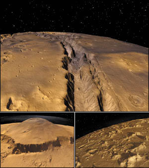
FOR AN UP-CLOSE VIEW of Mars, researchers at the Centre for Astrophysics and Supercomputing at the University of Swinburne in Australia used recent high-resolution NASA satellite images to render the surface of the planet, including accurate sun positions and shadows, correct rotation and position of the planet's two moons, and true star positions. The large image above shows the "Grand Canyon" of Mars, called the Mariner Valley. The smaller image at left is Olympus Mons, the highest known mountain in the solar system, and the right image shows the surface near a large crater called Dao. For rendering, the researchers used custom tools and the public-domain raytracer PovRay. The final animation consists of 24,000 frames rendered in stereo. One of the first visualizations of Mars at this resolution, the animation will be part of an IMAX show for the National Museum of Australia. -Diana Phillips Mahoney |